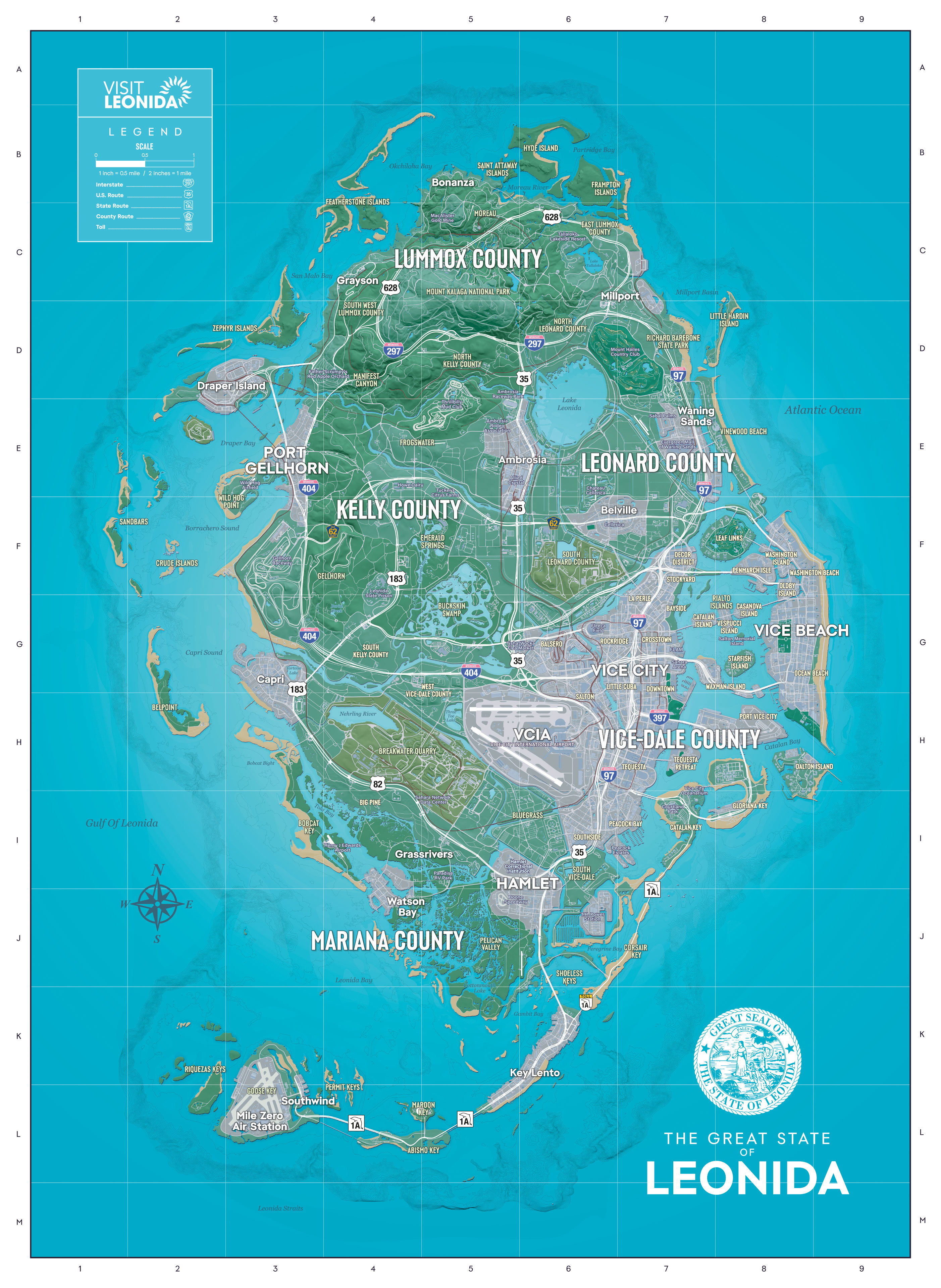
Download the official GTA 6 map
Rockstar made the map in two sizes. The print size is 5,775 × 7,900 pixels, 2.1 times as wide as the screen size, and it is what the Print button above uses. Save either one here, or from the Grand Theft Auto VI media page where Rockstar offers them.
Print size (JPG, 6.1 MB)Screen size (JPG, 2.2 MB)
Rockstar's file or this page?
Rockstar gives you one big picture. A home printer cannot fit it on one sheet at full size, and most print windows either shrink it until the street names blur or cut off the edges. This page does the printing part for you:
- It fits the map to US Letter, A4, Tabloid or A3, portrait or landscape.
- It splits a poster into numbered sheets that overlap by 1 cm, with cut lines and a layout sheet.
- It prints one of 6 areas on its own, so the names come out bigger.
- It can leave the sea white to save ink.
- It lists where each town sits on the map's grid.
How big will the poster be?
These are the finished sizes of the whole map once the sheets are taped together, with 1 cm of each sheet tucked under the next. Portrait sheets, printed at Actual size.
| Paper | Sheets across | Sheets to print | Poster size |
|---|---|---|---|
| US Letter | 2 | 6 | 15.3 × 21.0 in (39 × 53 cm) |
| US Letter | 3 | 12 | 22.8 × 31.2 in (58 × 79 cm) |
| US Letter | 4 | 20 | 30.3 × 41.5 in (77 × 105 cm) |
| A4 | 2 | 4 | 14.9 × 20.4 in (38 × 52 cm) |
| A4 | 3 | 9 | 22.1 × 30.3 in (56 × 77 cm) |
| A4 | 4 | 16 | 29.4 × 40.2 in (75 × 102 cm) |
Street names on the official map are small. To read them, print one area instead of the whole map: on the same number of sheets, Vice City and Vice Beach comes out 2.4 times as big as it does on the whole map.
Find a place on the map
The official map has its own grid: columns 1 to 9 along the top and rows A to M down the side. Each place below is listed by the square its name is printed in. Two squares, such as E5–E6, means the name sits across the line between them.
| Place | Square |
|---|---|
| Lummox County | C5 |
| Leonard County | E7 |
| Kelly County | F4 |
| Vice-Dale County | H7 |
| Mariana County | J4 |
| Bonanza | B5 |
| Grayson | C4 |
| Mount Kalaga National Park | C5 |
| Millport | C6–C7 |
| Draper Island | D2–D3 |
| Port Gellhorn | E3 |
| Ambrosia | E5–E6 |
| Lake Leonida | E6 |
| Waning Sands | E7 |
| Belville | F6–F7 |
| Capri | G3 |
| Vice City | G7 |
| Vice Beach | G8 |
| Vice City International Airport (VCIA) | H5–H6 |
| Big Pine | I4 |
| Grassrivers | I4–I5 |
| Hamlet | I5–I6 |
| Watson Bay | J4 |
| Key Lento | K6 |
| Southwind | L3 |
| Mile Zero Air Station | L3 |
What the official map shows
Roads, towns, parks, lakes and the 5 counties, with a compass and a scale bar (1 inch = 0.5 mile). The legend sorts the roads into Interstates, U.S. Routes, State Routes, County Routes and toll roads, each with its own shield.
It is a tourist map, so it has no mission markers or collectibles. Pin it next to the GTA 6 missions list and tick the story off as you travel. Cars you steal on the way can go to Moses.
How we check this page
The map is Rockstar's own artwork with nothing added; the print file only has its printer colours turned into screen colours. We measured its grid lines and read every place name and square off the map itself. Poster sizes come from the same sums the print tool uses. Last checked November 19, 2026. If something does not match your print, tell us.
Questions
Is there an official GTA 6 map?
Yes. Rockstar put its Leonida map poster on the Grand Theft Auto VI media page as a free download on launch day, in a screen size and a print size. This page prints from the print size, 5,775 × 7,900 pixels.
How do I print the GTA 6 map on one page?
Pick Whole map, your paper and 1 sheet across, then print at Actual size (100%). The whole state fits on one Letter or A4 sheet, centred with a white edge.
How do I print a big GTA 6 map poster at home?
Pick 2 to 4 sheets across. On US Letter, 2 across gives 6 sheets that tape into a poster about 15.3 × 21.0 in. Each sheet overlaps the next by 1 cm and a layout sheet shows where it goes.
What are the counties on the GTA 6 map?
The official map names 5: Lummox, Leonard, Kelly, Vice-Dale and Mariana. The county names are the biggest words on the map.
Where is Vice City on the GTA 6 map?
On the east side of Leonida, around square G7 of the map's grid. Vice Beach is the strip across the water in G8.
Can I print the GTA 6 map without the blue sea?
Yes. Tick Ink saver and the sea prints white, which saves most of the ink. Names written over the sea turn white with it, so keep it off if you want the legend box.